

Cloud Algorithm
 MODIS on Terra and Aqua provides unique spectral and spatial capability for retrieving cloud top and cloud optical properties. Relative to previous generation global imagers (e.g., AVHRR), MODIS has several additional spectral channels, including 1.6 and 2.1µm window channels that, in addition to an AVHRR heritage 3.7µm channel, provide cloud microphysical information. CO2-slicing channels (13µm spectral region) and the related cloud top algorithm have heritage with the HIRS instrument [e.g., Wylie and Menzel, 1999]. Native spatial resolution is at 250m (0.66 and 0.87µm channels), 500m (five channels including 3 shortwave-infrared), and 1km (all others).
Cloud Top Properties Algorithm
The cloud top properties (cloud top pressure, temperature, and effective cloud amount) are produced for the cloudy portion of the 5×5 pixel arrays wherein the cloud pixels identified by the probably cloudy and cloudy bits of the MOD35 cloud mask are averaged to reduce noise. The MODIS science team utilizes an extended suite of channels, in particular within the CO2 absorption region from 13.3 to 14.2µm. These so-called CO2-slicing channels have a long history of use in identifying cloud top pressure for high clouds due to the opacity of CO2, a uniformly mixed, but temporally changing, gas in the Earth’s atmosphere [Chahine, 1974; King et al., 1992]. They are, however, less capable of determining cloud top pressure (or altitude) for low boundary-layer clouds. In MODIS, the CO2-slicing channels are supplemented with an infrared window channel at 11µm for optically thicker and lower-level clouds. C6 improvements in the cloud top properties algorithm and changes in the product datasets have been described in the updated ATBD and in Baum et al. [2012], and include: (i) improved knowledge of the spectral response functions of the thermal infrared channels, based largely on comparison with corresponding hyperspectral measurements from collocated AIRS (Atmosphere Infrared Sounder) observations on Aqua, (ii) restrictions to the application of the CO2-slicing method based on the infrared phase retrieval information, (iii) introduction of surface emissivity maps, (iv) introduction of a latitude dependent 11µm brightness temperature lapse rate over the ocean, (v) improvements to the thermal infrared-derived thermodynamic phase, and (vi) introduction of cloud top properties using 1km spatial resolution.
Cloud Optical Properties Algorithm
Theoretical basis of primary cloud optical properties algorithm
The simultaneous retrieval of cloud optical thickness (COT) and effective radius (CER) is best achieved by simultaneously measuring the reflection function in a non-absorbing and absorbing spectral channel (e.g., VIS/NIR and SWIR, respectively), and comparing the resulting measurements with theoretical forward model calculations, as demonstrated with airborne data by Nakajima and King [1990] (also see historical papers on airborne/spaceborne observations and retrievals by Twomey and Cocks [1982, 1987], Curran and Wu [1982], Rawlins and Foot [1990], Nakajima et al. [1991], Han et al. [1994], Platnick and Twomey [1994], Platnick and Valero [1995], Minnis et al. [1997]). The technique is especially accurate over dark ocean surfaces because the reflection function of the earth–atmosphere system arises primarily from light scattering by the cloud layer, with little influence from the underlying surface. In comparing measurements with theory, however, it is essential that the light-scattering properties of the cloud are modeled realistically, and that the cloud is properly ascribed to either a liquid water or ice cloud with corresponding optical properties. For applications of this technique to global observations, involving clouds over snow and sea ice surfaces, or various land surfaces, it is further necessary to estimate realistic values of the underlying surface reflectance in the appropriate channels.
Figure 1 below illustrates the underlying principle behind the simultaneous retrieval of COT and CER from reflected solar radiation measurements for (a) liquid water clouds and (b) ice clouds, shown here for clouds over snow and sea ice surfaces. The minimum values of the reflection function at 1.24 and 2.13µm correspond to the reflection functions of the underlying surface at those wavelengths in the absence of an atmosphere. The dashed curves represent reflection function contours for fixed COT, and the solid curved contours are for fixed CER. Over snow and sea ice surfaces, as shown here, the reflection function of liquid water clouds at 1.24µm decreases as COT increases from 0 to about 2, where it begins to increase; over land (ocean) surfaces where 0.66µm (0.87µm) is used instead, the reflection function of the surface is small and this would not be the case.
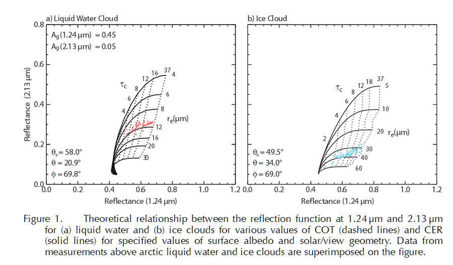
The data points superimposed on the theoretical curves of Fig. 1 correspond to Aqua MODIS observations over Greenland, acquired at the observational solar and viewing directions specified in the figures on July 28 (1345UTC) and 29 (1250UTC) 2008 for ice and liquid water clouds, respectively.
Other channel pairs can be used to retrieve COT and CER. While the primary or standard channel pair uses the 2.13µm channel for microphysical information, the 1.63µm and 3.79µm MODIS channels can also be used as described in Sect. 2. The next subsection describes an alternate retrieval using two SWIR channels to minimize errors over snow and ice surfaces that was first implemented in C5 processing.
Theoretical basis of 1.6 and 2.1µm cloud optical properties algorithm
Due to the relatively high surface albedo at 0.87µm or alternatively 1.24µm (used in standard retrievals) over snow and sea ice surfaces, Platnick et al. [2001] proposed an alternative method for simultaneously retrieving COT and CER from reflectance measurements. This method takes advantage of the fact that the surface albedo of snow and sea ice is quite low at 1.63µm (cf. Moody et al. [2007]). Figure 2[KM1] illustrates the theoretical relationship and corresponding data points of the simultaneous retrieval of COT and CER using measurements at 1.63 and 2.13µm, where it is assumed that the surface albedo of sea ice is 0.03 at both wavelengths. Although the solution space loses the near-orthogonality of the COT and CER retrievals using standard channel pairs, and therefore is more sensitive to calibration uncertainties in the measurements, the sensitivity to COT is generally better than the standard method because of decreased uncertainty in the value of the surface albedo.
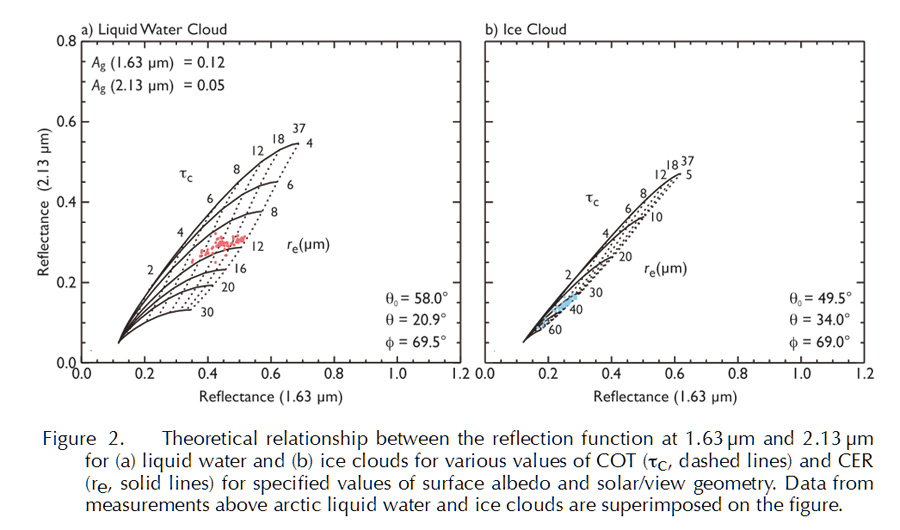
This technique is noticeably more robust for liquid water clouds (left panel in Figure 2, above) than for ice clouds, however, where the more appreciable lack of orthogonality is apparent (right panel in Figure 2, above).
MODIS applies this supplemental cloud optical properties retrieval for COT and CER over the ocean as well as snow and sea ice surfaces, in addition to the standard algorithm, a feature that was first implemented in C5.