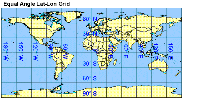
Equal Angle Grid
The Monthly (08_M3) product is computed and stored on an equal angle lat-lon grid. The grid cells are 1 degree by 1 degree, which means the output grid is always 360 pixels in width and 180 pixels in length. The major implication of this relatively low grid resolution is these product maps are not good candidates for printing, however they are fine for viewing on video monitors as well as for model input. The first (upper left) grid position (1,1) corresponds to a 1 degree box centered at latitude 89.5 and longitude -179.5. The convention used here is positive latitudes are degrees north and positive longitudes are degrees east, allowing lat/lon pairs to increase from top to bottom and left to right on the grid. Therefore, the first grid (1,1) corresponds to a 1 degree box centered at 89.5N and 179.5W.
Land/Ocean Mask
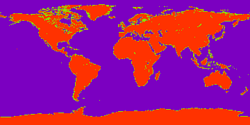
A Land/Ocean Mask for L3 products is provided below. The PNG image is 360 pixels in width and 180 pixels in height. Each image pixel corresponds to one L3 1x1 degree grid cell. Values of 200 represent land grid cells, values of 100 represent mixed grid cells, and values of 0 represent ocean grid cells. This image can be use with analysis programs, such as those written in IDL, to screen L3 results for ocean or land only.