

 Atm. Profile Product (07_L2) File Format Basics
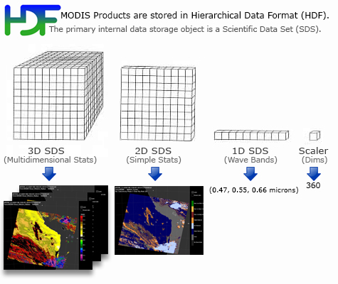
Cloud (06_L2) Product files are stored in Hierarchical Data Format (HDF). HDF is a multi-object file format for sharing scientific data in multi-platform distributed environments. HDF files should only be accessed through HDF library subroutine and function calls, which can be downloaded from the HDF web site. Each of the parameters listed below is stored as a Scientific Data Set (SDS) within the HDF file.
Atm. Profile Product (07_L2) Scientific Data Sets
(Primary SDS's only, not a complete list)
Dimension List
MOD07_L2 Dimension List
- Cell_Along_Swath = 406 (typical)
- Cell_Across_Swath = 270 (typical)
- Band_Number = 15
- Pressure_Level = 20
- Output_Parameter = 10
- Water_Vapor_QA_Bytes = 5
MOD07_L2 Scientific Data Set (SDS) List
Geolocation and Time Parameters
- Latitude
Description: Geodetic Latitude
Dimensions: (Cell_Along_Swath, Cell_Across_Swath)
Valid Range: -90 to +90 degrees north - Longitude
Description: Geodetic Longitude
Dimensions: (Cell_Along_Swath, Cell_Across_Swath)
Valid Range: -180 to +180 degrees east - Scan_Start_Time
Description: International Atomic Time at Start of Scan replicated across the Swath
Dimensions: (Cell_Along_Swath, Cell_Across_Swath)
Valid Range: 0.0 to 3.1558E+9 seconds since 1 January 1993 00:00:00
Solar and Viewing Geometry Parameters
- Solar_Zenith
Description: Solar Zenith Angle, Cell to Sun
Dimensions: (Cell_Along_Swath, Cell_Across_Swath)
Valid Range: 0 to +180 degrees - Solar_Azimuth
Description: Solar Azimuth Angle, Cell to Sun
Dimensions: (Cell_Along_Swath, Cell_Across_Swath)
Valid Range: -180 to +180 degrees - Sensor_Zenith
Description: Sensor Zenith Angle, Cell to Sensor
Dimensions: (Cell_Along_Swath, Cell_Across_Swath)
Valid Range: 0 to 180 degrees - Sensor_Azimuth
Description: Sensor Azimuth Angle, Cell to Sensor
Dimensions: (Cell_Along_Swath, Cell_Across_Swath)
Valid Range: -180 to 180 degrees
Science Parameters
- Brightness_Temperature
Description: Brightness Temperature
Dimensions: (Band_Number, Cell_Along_Swath, Cell_Across_Swath)
Valid Range: 150 to 350 K - Skin_Temperature
Description: Surface_Temperature
Dimensions: (Cell_Along_Swath, Cell_Across_Swath)
Valid Range: 150 to 350 K - Surface_Pressure
Description: Surface_Pressure
Dimensions: (Cell_Along_Swath, Cell_Across_Swath)
Valid Range: 800 to 1100 hPa - Surface_Elevation
Description: Surface_Elevation
Dimensions: (Cell_Along_Swath, Cell_Across_Swath)
Valid Range: -400 to 8840 meters - Processing_Flag
Description: Processing_Flag
Dimensions: (Cell_Along_Swath, Cell_Across_Swath)
Valid Range: byte array - Tropopause_Height
Description: Tropopause_Height
Dimensions: (Cell_Along_Swath, Cell_Across_Swath)
Valid Range: 1 to 1100 hPa - Guess_Temperature_Profile
Description: Guess_Temperature_Profile
Dimensions: (Pressure_Level, Cell_Along_Swath, Cell_Across_Swath)
Valid Range: 150 to 350 K - Guess_Moisture_Profile
Description: Guess Dew Point Temperature Profile
Dimensions: (Pressure_Level, Cell_Along_Swath, Cell_Across_Swath)
Valid Range: 150 to 350 K - Retrieved_Temperature_Profile
Description: Retrieved Temperature Profile
Dimensions: (Pressure_Level, Cell_Along_Swath, Cell_Across_Swath)
Valid Range: 150 to 350 K - Retrieved_Moisture_Profile
Description: Retrieved Dew Point Temperature Profile
Dimensions: (Pressure_Level, Cell_Along_Swath, Cell_Across_Swath)
Valid Range: 150 to 350 K - Retrieved_Height_Profile
Description: Retrieved Geopotential Height Profile
Dimensions: (Pressure_Level, Cell_Along_Swath, Cell_Across_Swath)
Valid Range: 0 to 65000 meters - Total_Ozone
Description: Total Ozone Burden
Dimensions: (Cell_Along_Swath, Cell_Across_Swath)
Valid Range: 0 to 500 Dobson units - Total_Totals
Description: Total Totals
Dimensions: (Cell_Along_Swath, Cell_Across_Swath)
Valid Range: 0 to 80 K - Lifted_Index
Description: Lifted Index
Dimensions: (Cell_Along_Swath, Cell_Across_Swath)
Valid Range: -20 to 40 K - K_Index
Description: K Index
Dimensions: (Cell_Along_Swath, Cell_Across_Swath)
Valid Range: 268 to 340 K - Water_Vapor
Description: Total Column Precipitable Water Vapor - IR Retrieval
Dimensions: (Cell_Along_Swath, Cell_Across_Swath)
Valid Range: 0 to 20 cm - Water_Vapor_Direct
Description: Total Column Precipitable Water Vapor - Direct IR Retrieval
Dimensions: (Cell_Along_Swath, Cell_Across_Swath)
Valid Range: 0 to 20 cm - Water_Vapor_Low
Description: Precipitable Water Vapor Low - IR Retrieval
Dimensions: (Cell_Along_Swath, Cell_Across_Swath)
Valid Range: 0 to 20 cm - Water_Vapor_High
Description: Precipitable Water Vapor High - IR Retrieval
Dimensions: (Cell_Along_Swath, Cell_Across_Swath)
Valid Range: 0 to 20 cm
Quality Assurance
- Quality_Assurance
Description: Quality Assurance Parameters
Dimensions: (Cell_Along_Swath, Cell_Across_Swath, Output_Parameter)
Valid Range: bit field - Quality_Assurance_Infrared
Description: Runtime Quality Assurance Flags for Water_Vapor_Infrared
Dimensions: (Cell_Along_Swath, Cell_Across_Swath, Water_Vapor_QA_Bytes)
Valid Range: bit field
Cloud Mask
- Cloud_Mask
Description: MODIS Cloud Mask , First Byte
Dimensions: (Cell_Along_Swath, Cell_Across_Swath)
Valid Range: bit field
Flag Interpretation: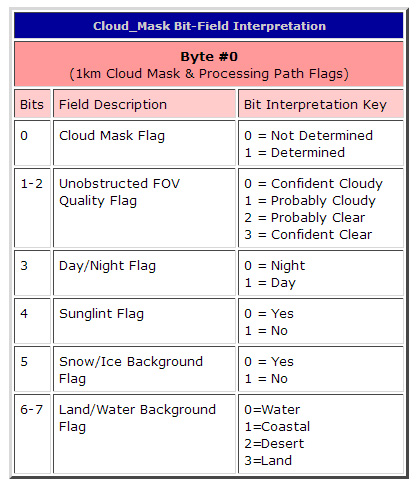
MOD07_L2 VData (Tables) List
- Band_Number
Description: MODIS Band Number
Dimensions: (Band_Number)
Data Values: 20, 22, 23, 24, 25, 27, 28, 29, 30, 31, 32, 33, 34, 35, 36 - Pressure_Level
Description: Pressure Levels of Profiles
Dimensions: (Band_Number)
Data Values: 05., 10., 20., 30., 50., 70., 100., 150., 200., 250., 300., 400., 500., 620., 700., 780., 850., 920., 950., 1000.
Units: hPa