

 Cloud Product (06_L2) File Format Basics
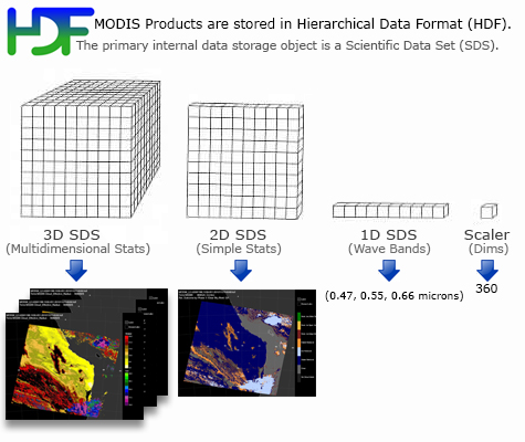
Cloud (06_L2) Product files are stored in Hierarchical Data Format (HDF). HDF is a multi-object file format for sharing scientific data in multi-platform distributed environments. HDF files should only be accessed through HDF library subroutine and function calls, which can be downloaded from the HDF web site. Each of the parameters listed below is stored as a Scientific Data Set (SDS) within the HDF file.
Cloud Product (06_L2) Scientific Data Sets
(Primary SDS's only, not a complete list)
Dimension List
- Cell_Along_Swath_5km = 406
- Cell_Across_Swath_5km = 270
- Cell_Along_Swath_1km = 2030
- Cell_Across_Swath_1km = 1354
- Band_Number = 7
- Band_Ratio = 5
- Band_Forcing = 5
- Band_Difference = 2
- Radius_Difference = 2
- QA_Parameter_5km = 10
- QA_Parameter_1km = 5
- Cloud_Mask_1km_Num_Bytes = 2
- Number_of_Instrument_Scans = 203 (typical)
- Maximum_Number_of_1km_Frames = 1354 (typical)
Geolocation and Time Parameters
- Longitude
Description: Geodetic Longitude
Dimensions: (Cell_Along_Swath_5km, Cell_Across_Swath_5km)
Valid Range: -180 to +180 degrees east - Latitude
Description: Geodetic Latitude
Dimensions: (Cell_Along_Swath_5km, Cell_Across_Swath_5km)
Valid Range: -90 to +90 degrees north - Scan_Start_Time
Description: International Atomic Time at Start of Scan replicated across the Swath
Dimensions: (Cell_Along_Swath_5km, Cell_Across_Swath_5km)
Valid Range: 0.0 to 3.1558E+9 seconds since 1 January 1993 00:00:00
Solar and Viewing Geometry Parameters
- Solar_Zenith
Description: Solar Zenith Angle, Cell to Sun
Dimensions: (Cell_Along_Swath_5km, Cell_Across_Swath_5km)
Valid Range: 0 to +180 degrees - Solar_Azimuth
Description: Solar Azimuth Angle, Cell to Sun
Dimensions: (Cell_Along_Swath_5km, Cell_Across_Swath_5km)
Valid Range: -180 to +180 degrees - Sensor_Zenith
Description: Sensor Zenith Angle, Cell to Sensor
Dimensions: (Cell_Along_Swath_5km, Cell_Across_Swath_5km)
Valid Range: 0 to 180 degrees - Sensor_Azimuth
Description: Sensor Azimuth Angle, Cell to Sensor
Dimensions: (Cell_Along_Swath_5km, Cell_Across_Swath_5km)
Valid Range: -180 to 180 degrees
Cloud Top Parameters (5km)
Note that separate Near Nadir (SZA LE 32) Retrievals are stored in (similar/parallel) SDS's with the string "Nadir" in the SDS name. These generally are more reliable than regular retrievals, since they only contain ONLY data that was retrieved with a less oblique instrument scanner view.
- Brightness_Temperature
Description: Brightness Temperature for MODIS Bands 29, 31, 32, 33, 34, 35, and 36
Dimensions: (Band_Number ,Cell_Along_Swath_5km, Cell_Across_Swath_5km)
Valid Range: 150 to 350 K - Surface_Temperature
Description: Surface Temperature
Dimensions: (Cell_Along_Swath_5km, Cell_Across_Swath_5km)
Valid Range: 150 to 350 K - Surface_Pressure
Description: Surface Pressure
Dimensions: (Cell_Along_Swath_5km, Cell_Across_Swath_5km)
Valid Range: 800 to 1100 hPa - Processing_Flag
Description: Cloud Retrieval Method Flag
Dimensions: (Cell_Along_Swath_5km, Cell_Across_Swath_5km)
Valid Range: (byte array) - Cloud_Height_Method
Description: Cloud Height Method
Dimensions: (Cell_Along_Swath_5km, Cell_Across_Swath_5km)
Valid Range: (byte array, with values from 1 to 6)
Detail: The cloud height method index indicates if a CO2-slicing retrieval or window channel retrieval was output.
Further, if a CO2-slicing retrieval was output, it specifies the MODIS band pair used to generate the result.
The index ranges from 1 to 6, defined as follows: 1 = Bands 36/35, 2 = Bands 35/34, 3 = Bands 35/33,
4 = Bands 34/33, 5 = Bands 33/31 (not used), 6 = Window channel method. - Cloud_Top_Pressure
Description: Cloud Top Pressure
Dimensions: (Cell_Along_Swath_5km, Cell_Across_Swath_5km)
Valid Range: 1 to 1100 hPa - Cloud_Top_Pressure_Day
Description: Cloud Top Pressure for daytime scenes
Dimensions: (Cell_Along_Swath_5km, Cell_Across_Swath_5km)
Valid Range: 1 to 1100 hPa - Cloud_Top_Pressure_Night
Description: Cloud Top Pressure for nighttime scenes
Dimensions: (Cell_Along_Swath_5km, Cell_Across_Swath_5km)
Valid Range: 1 to 1100 hPa - Cloud_Top_Temperature
Description: Cloud Top Temperature
Dimensions: (Cell_Along_Swath_5km, Cell_Across_Swath_5km)
valid_range: 150 to 350 K - Cloud_Top_Temperature_Day
Description: Cloud Top Temperature for daytime scenes
Dimensions: (Cell_Along_Swath_5km, Cell_Across_Swath_5km)
valid_range: 150 to 350 K - Cloud_Top_Temperature_Night
Description: Cloud Top Temperature for nighttime scenes
Dimensions: (Cell_Along_Swath_5km, Cell_Across_Swath_5km)
valid_range: 150 to 350 K - Cloud_Top_Height
Description: Cloud Top Height
Dimensions: (Cell_Along_Swath_5km, Cell_Across_Swath_5km)
Valid Range: 1 to 18,000 m
Notes: The highest retrieved is about 96 hPa which translates to about 55000 ft in a tropical atmosphere. Therefore the retrieval is capped at 96 hPa so 18000 m (or 59,055 ft) as a valid range should be good. - Cloud_Top_Height_Day
Description: Cloud Top Height for daytime scenes
Dimensions: (Cell_Along_Swath_5km, Cell_Across_Swath_5km)
Valid Range: 1 to 18,000 m
Notes: The highest retrieved is about 96 hPa which translates to about 55000 ft in a tropical atmosphere. Therefore the retrieval is capped at 96 hPa so 18000 m (or 59,055 ft) as a valid range should be good. - Cloud_Top_Height_Night
Description: Cloud Top Height for nighttime scenes
Dimensions: (Cell_Along_Swath_5km, Cell_Across_Swath_5km)
Valid Range: 1 to 18,000 m
Notes: The highest retrieved is about 96 hPa which translates to about 55000 ft in a tropical atmosphere. Therefore the retrieval is capped at 96 hPa so 18000 m (or 59,055 ft) as a valid range should be good. - Tropopause_Height
Description: Tropopause Height
Dimensions: (Cell_Along_Swath_5km, Cell_Across_Swath_5km)
Valid Range: 1 to 18,000 m - Cloud_Fraction
Description: Cloud Fraction
Dimensions: (Cell_Along_Swath_5km, Cell_Across_Swath_5km)
Valid Range: (byte array) - Cloud_Fraction_Day
Description: Cloud Fraction for daytime scenes
Dimensions: (Cell_Along_Swath_5km, Cell_Across_Swath_5km)
Valid Range: (byte array) - Cloud_Fraction_Night
Description: Cloud Fraction for nighttime scenes
Dimensions: (Cell_Along_Swath_5km, Cell_Across_Swath_5km)
Valid Range: (byte array) - Cloud_Effective_Emissivity
Description: Cloud Effective Emissivity
Dimensions: (Cell_Along_Swath_5km, Cell_Across_Swath_5km)
Valid Range: (byte array) - Cloud_Effective_Emissivity_Day
Description: Cloud Effective Emissivity for daytime scenes
Dimensions: (Cell_Along_Swath_5km, Cell_Across_Swath_5km)
Valid Range: (byte array) - Cloud_Effective_Emissivity_Night
Description: Cloud Effective Emissivity for nighttime scenes
Dimensions: (Cell_Along_Swath_5km, Cell_Across_Swath_5km)
Valid Range: (byte array) - Cloud_Top_Pressure_Infrared
Description: Cloud Top Pressure from IR Window
Dimensions: (Cell_Along_Swath_5km, Cell_Across_Swath_5km)
Valid Range: 1 to 1100 hPa - Spectral_Cloud_Forcing
Description: Spectral Cloud Forcing
Dimensions: (Band_Forcing, Cell_Along_Swath_5km, Cell_Across_Swath_5km)
Valid Range: -20 to 20 watts/meter2/steradian/micron - Cloud_Top_Pressure_From_Ratios
Description: Cloud top pressure from ratios (36/35, 35/34, 35/33, 34/33, 33/31)
Dimensions: (Band_Ratio, Cell_Along_Swath_5km, Cell_Across_Swath_5km)
Valid Range: 1 to 1100 hPa - Surface_Type
Description: Surface Type based on Emissivity
Dimensions: (Cell_Along_Swath_5km, Cell_Across_Swath_5km)
Valid Range: 0 to 200 - Radiance_Variance
Description: Radiance Variance for MODIS Bands 29, 31, 32, 33, 34, 35, and 36
Dimensions: (Band_Number, Cell_Along_Swath_5km, Cell_Across_Swath_5km)
Valid Range: 0.00 to 0.20 watts/meter2/steradian/micron - Brightness_Temperature_Difference
Description: Brightness Temperature Difference (Bands 29-31 & 31-32)
Dimensions: (Band_Difference, Cell_Along_Swath_5km, Cell_Across_Swath_5km)
Valid Range: -20 to 300 K -
Cloud_Phase_Infrared
Description: Cloud Phase Infrared
Dimensions: (Cell_Along_Swath_5km, Cell_Across_Swath_5km)
Valid Range: (byte array) clear = 0; liquid water clouds = 1; ice clouds = 2; undetermined phase clouds = 6.(Note there are no mixed phase clouds (=3) in C6 and later)
-
Cloud_Phase_Infrared_Day
Description: Cloud Phase Infrared for daytime scenes
Dimensions: (Cell_Along_Swath_5km, Cell_Across_Swath_5km)
Valid Range: (byte array) clear = 0; liquid water clouds = 1; ice clouds = 2; undetermined phase clouds = 6.(Note there are no mixed phase clouds (=3) in C6 and later)
-
Cloud_Phase_Infrared_Night
Description: Cloud Phase Infrared for nighttime scenes
Dimensions: (Cell_Along_Swath_5km, Cell_Across_Swath_5km)
Valid Range: (byte array) clear = 0; liquid water clouds = 1; ice clouds = 2; undetermined phase clouds = 6.(Note there are no mixed phase clouds (=3) in C6 and later)
- Cloud_Mask_5km
Description: MODIS cloud mask, first byte
Dimensions: (Cell_Along_Swath_5km, Cell_Across_Swath_5km)
Valid Range: (byte array) - Quality_Assurance_5km
Description: Quality Assurance at 5x5 km resolution
Dimensions: (Cell_Along_Swath_5km, Cell_Across_Swath_5km, QA_Parameter_5km)
Valid Range: (byte array) - Band_Number
Description: MODIS Band Number
Dimensions: (Band_Number)
Valid Range: (vdata table array)
Cloud Optical Parameters (1km)
Note that seperate Partly Cloudy Retrievals are stored in (similar/parallel) SDS's with the string "_PCL" in the SDS name. These generally have higher uncertainties than regular cloudy scene retrievals, and data users should use a bit more caution and care with these PCL retrievals.
Cloud Optical Properties Primary Cloud Retrieval
- Cloud_Optical_Thickness
Description: Cloud Optical Thickness
Dimensions: (Cell_Along_Swath_1km, Cell_Across_Swath_1km)
Valid Range: 0 to 100 - Cloud_Optical_Thickness_Uncertainty
Description: Cloud Optical Thickness Relative Uncertainty (Percent)
Dimensions: (Cell_Along_Swath_1km, Cell_Across_Swath_1km)
Valid Range: 0 to 200% - Cloud_Effective_Radius
Description: Cloud Effective Particle Radius
Dimensions: (Cell_Along_Swath_1km, Cell_Across_Swath_1km)
Valid Range: 0 to 90 µm - Cloud_Effective_Radius_Uncertainty
Description: Cloud Effective Particle Radius Relative Uncertainty (Percent)
Dimensions: (Cell_Along_Swath_1km, Cell_Across_Swath_1km)
Valid Range: 0 to 200% - Effective_Radius_Difference
Description: Cloud Particle Effective Radius two-channel retrieval using band 6 and band 20 differenced from band 7 retrieval and either band 1, 2, 5 (specified in Quality_Assurance_1km). Dimension 1 of SDS is band 6 - band 7 retrieval, Dimension 2 is band 20 - band 7 retrieval
Dimensions: (Radius_Difference, Cell_Along_Swath_1km, Cell_Across_Swath_1km, Radius_Difference)
Valid Range: -90 to 90 µm - Cloud_Water_Path
Description: Column Water Path two-band retrieval using band 7 and either band 1, 2, 5 (specified in Quality_Assurance_1km)
Dimensions: (Cell_Along_Swath_1km, Cell_Across_Swath_1km)
Valid Range: 0 to 9000 g/m^2 - Cloud_Water_Path_Uncertainty
Description: Column Water Path Relative Uncertainty (Percent)
Dimensions: (Cell_Along_Swath_1km, Cell_Across_Swath_1km)
Valid Range: 0 to 9000 g/m^2 - Cloud_Phase_Optical_Properties
Description: Cloud Phase Determination Used in Optical Thickness/Effective Radius Retrieval
Dimensions: (Cell_Along_Swath_1km, Cell_Across_Swath_1km)
Valid Range: 0 to 4 (0=fill, 1=clear, 2=liquid water cloud, 3=ice cloud, 4=undetermined phase cloud) - Cloud_Multi_Layer_Flag
Description: Cloud Multi Layer Identification From MODIS Shortwave Observations
Dimensions: (Cell_Along_Swath_1km, Cell_Across_Swath_1km)
Valid Range: 0 to 8 (0=fill, 1=single layer, 2 through 8=increasing confidence of multilayer clouds)
Cloud Optical Properties 1.6 / 2.1 micron Cloud Retrieval
- Cloud_Optical_Thickness_1621
Description: Cloud Optical Thickness two-channel retrieval using band 6 and band 7
Dimensions: (Cell_Along_Swath_1km, Cell_Across_Swath_1km)
Valid Range: 0 to 100 - Cloud_Optical_Thickness_Uncertainty_1621
Description: Cloud Optical Thickness Relative Uncertainty (Percent) two-channel retrieval using band 6 and band 7
Dimensions: (Cell_Along_Swath_1km, Cell_Across_Swath_1km)
Valid Range: 0 to 100 - Cloud_Effective_Radius_1621
Description: Cloud Effective Particle Radius Relative Uncertainty (Percent) two-channel retrieval using band 6 and band 7
Dimensions: (Cell_Along_Swath_1km, Cell_Across_Swath_1km)
Valid Range: 0 to 90 µm - Cloud_Effective_Radius_Uncertainty_1621
Description: Cloud Effective Particle Radius Relative Uncertainty (Percent) two-channel retrieval using band 6 and band 7
Dimensions: (Cell_Along_Swath_1km, Cell_Across_Swath_1km)
Valid Range: 0 to 90 µm - Cloud_Water_Path_1621
Description: Column Water Path two-band retrieval using band 6 and band 7
Dimensions: (Cell_Along_Swath_1km, Cell_Across_Swath_1km)
Valid Range: 0 to 9000 g/m^2 - Cloud_Water_Path_Uncertainty_1621
Description: Column Water Path Relative Uncertainty (Percent) two-band retrieval using band 6 and band 7
Dimensions: (Cell_Along_Swath_1km, Cell_Across_Swath_1km)
Valid Range: 0 to 9000 g/m^2
Cloud Optical Properties 1.6 micron Cloud Retrieval
- Cloud_Optical_Thickness_16
Description: Cloud Optical Thickness two-channel retrieval using band 6 and either band 1, 2, 5
Dimensions: (Cell_Along_Swath_1km, Cell_Across_Swath_1km)
Valid Range: 0 to 100 - Cloud_Optical_Thickness_Uncertainty_16
Description: Cloud Optical Thickness Relative Uncertainty (Percent) two-channel retrieval using band 6 and either band 1, 2, 5
Dimensions: (Cell_Along_Swath_1km, Cell_Across_Swath_1km)
Valid Range: 0 to 100 - Cloud_Effective_Radius_16
Description: Cloud Effective Particle Radius Relative Uncertainty (Percent) two-channel retrieval using band 6 and either band 1, 2, 5
Dimensions: (Cell_Along_Swath_1km, Cell_Across_Swath_1km)
Valid Range: 0 to 90 µm - Cloud_Effective_Radius_Uncertainty_16
Description: Cloud Effective Particle Radius Relative Uncertainty (Percent) two-channel retrieval using band 6 and either band 1, 2, 5
Dimensions: (Cell_Along_Swath_1km, Cell_Across_Swath_1km)
Valid Range: 0 to 90 µm - Cloud_Water_Path_16
Description: Column Water Path two-band retrieval using band 6 and either band 1, 2, 5
Dimensions: (Cell_Along_Swath_1km, Cell_Across_Swath_1km)
Valid Range: 0 to 9000 g/m^2 - Cloud_Water_Path_Uncertainty_16
Description: Column Water Path Relative Uncertainty (Percent) two-band retrieval using band 6 and either band 1, 2, 5
Dimensions: (Cell_Along_Swath_1km, Cell_Across_Swath_1km)
Valid Range: 0 to 9000 g/m^2
Cloud Optical Properties 3.7 micron Cloud Retrieval
- Cloud_Optical_Thickness_37
Description: Cloud Optical Thickness two-channel retrieval using using band 20 and either band 1, 2, 5
Dimensions: (Cell_Along_Swath_1km, Cell_Across_Swath_1km)
Valid Range: 0 to 100 - Cloud_Optical_Thickness_Uncertainty_37
Description: Cloud Optical Thickness Relative Uncertainty (Percent) two-channel retrieval using band 20 and either band 1, 2, 5
Dimensions: (Cell_Along_Swath_1km, Cell_Across_Swath_1km)
Valid Range: 0 to 100 - Cloud_Effective_Radius_37
Description: Cloud Effective Particle Radius Relative Uncertainty (Percent) two-channel retrieval using band 20 and either band 1, 2, 5
Dimensions: (Cell_Along_Swath_1km, Cell_Across_Swath_1km)
Valid Range: 0 to 90 µm - Cloud_Effective_Radius_Uncertainty_37
Description: Cloud Effective Particle Radius Relative Uncertainty (Percent) two-channel retrieval using band 20 and either band 1, 2, 5
Dimensions: (Cell_Along_Swath_1km, Cell_Across_Swath_1km)
Valid Range: 0 to 90 µm - Cloud_Water_Path_37
Description: Column Water Path two-band retrieval using band 20 and either band 1, 2, 5
Dimensions: (Cell_Along_Swath_1km, Cell_Across_Swath_1km)
Valid Range: 0 to 9000 g/m^2 - Cloud_Water_Path_Uncertainty_37
Description: Column Water Path Relative Uncertainty (Percent) two-band retrieval using band 20 and either band 1, 2, 5
Dimensions: (Cell_Along_Swath_1km, Cell_Across_Swath_1km)
Valid Range: 0 to 9000 g/m^2
Cloud Optical Properties Bit Strings (Cloud Mask and QA Flags)
- Cloud_Mask_1km
Description: MODIS Cloud Mask, first byte
Dimensions: (Cell_Along_Swath_1km, Cell_Across_Swath_1km)
Valid Range: (byte array)
Noteworthy: Internal 06_L2 documentation notes that Unobstructed FOV Flag = 1 means "Uncertain" it should read "Probably Cloudy" as noted below
Flag Interpretation: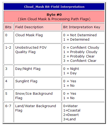
- Quality_Assurance_1km
Description: QA Flags at 1x1 km resolution
Dimensions: (Cell_Along_Swath_1km, Cell_Across_Swath_1km, QA_Parameter_1km)
Valid Range: (byte array)
Detail: (See QA Plan for detail)
Cirrus Detection Parameters (1km)
- Cirrus_Reflectance
Description: Cirrus Reflectance
Dimensions: (Cell_Along_Swath_1km, Cell_Across_Swath_1km)
Valid Range: 0 to 1 - Cirrus_Reflectance_Flag
Description: Cirrus Reflectance Flag
Dimensions: (Cell_Along_Swath_1km, Cell_Across_Swath_1km)
Valid Range: (byte array)