

Eight Day Product (08_E3) File Format Basics
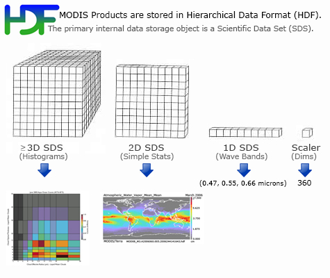
MODIS Atmosphere Eight Day (08_E3) product files are stored in Hierarchical Data Format (HDF). HDF is a multi-object file format for sharing scientific data in multi-platform distributed environments. HDF files should only be accessed through HDF library subroutine and function calls, which can be downloaded from the HDF web site.
Each of the global gridded statistical fields within the HDF file is stored as a Scientific Data Set (SDS). L3 Atmosphere products contain hundreds of 1°×1° global gridded Scientific Data Sets (SDSs) or statistics derived from 8 consecutive days of the Daily (08_D3) product. (The Daily product is derived from L2 products of Aerosol (04_L2), Water Vapor (05_L2), Cloud (06_L2), and Atmospheric Profile (07_L2)). The grid domain or size is 360x180 pixels, which corresponds to 360 degrees of longitude and 180 degrees of latitude.
There are a number of general L3 Eight Day algorithm characteristics:
- Only the L3 Daily files are used as input. (Greatly improves algorithm efficiency.)
- L3 Daily and L3 Multiday HDF files use an identical grid, SDS dimensions, and histogram bin definitions. (This is an algorithm requirement.)
- There is no “valid range” check, only “Fill_Value” L3 Daily (08_D3) grid cells are universally excluded from L3 Multiday statistics.
- One of two weighting schemes are used to compute Eight Day statistics from Daily statistics:
- Unweighted, where each L3 Daily grid cell is given equal weight in the L3 Multiday mean. This is a simple time-averaged mean, useful for computing such things as temperature averages over a multi-day period.
- Pixel Count Weighted, where each L3 Daily grid cell is weighted by the valid L2 Pixel Counts in that grid. This is a count-averaged mean that ensures computed means match means computed from histograms -- useful for example, for cloud optical properties.
Eight Day Product File (08_E3) Parameter List (primary parameters only)
| Parameters derived from the L2 Aerosol (04_L2) Product | |
|
Aerosol Combined Ocean and Land |
|
| Scattering_Angle | Derived from the 04_L2 SDS "Scattering_Angle". |
| Aerosol_Optical_Depth_Land_Ocean | Derived from the 04_L2 SDS "Optical_Depth_Land_And_Ocean". Note that the land part of this SDS is taken from the 04_L2 SDS Corrected_Optical_Depth_Land at 0.55 microns and the ocean part of this SDS is taken from the 04_L2 SDS Effective_Optical_Depth_Best_Ocean (a parameter that is not propagated into L3 by itself). |
|
Aerosol Land Only |
|
| Aerosol_Optical_Depth_Land | Derived from the 04_L2 SDS "Corrected_Optical_Depth_Land". Three solutions (computed at 0.47, 0.55, and 0.66 microns) are retained. Note that this parameter group contains three joint histograms for optical depth computed using 0.47 vs. 0.55 microns, 0.47 vs. 0.66 microns, and 0.55 vs. 0.66 microns. |
|
Aerosol Ocean Only |
|
| Aerosol_Optical_Depth_Average_Ocean | Derived from the 04_L2 SDS "Effective_Optical_Depth_Average_Ocean". |
| Aerosol_Optical_Depth_Small_Ocean | Derived from the 04_L2 SDS "Optical_Depth_Ratio_Small_Ocean_0.55micron". Only the L2 "best" solution is retained in L3. The "average" solution is computed in L2 but not propagated to L3. |
| Aerosol_PSML003_Ocean | Derived from the 04_L2 SDS "Cloud_Condensation_Nuclei_Ocean". |
| Aerosol_Optical_Depth_by_models_ocean | Derived from the 04_L2 SDS "Optical_Depth_by_models_ocean". The parameter has solutions at 9 models. |
| AEROSOL: DEEP BLUE () | |
| Deep_Blue_Aerosol_Optical_Depth_Land | Derived from the 04_L2 SDS "Deep_Blue_Aerosol_Optical_Depth_Land ". |
| AOD_550_Dark_Target_Deep_Blue_Combined | Derived from the 04_L2 SDS "". Combines Dark Target and Deep Blue Aerosol. |
| Parameters derived from the L2 Water Vapor (05_L2) Product | |
|
Water Vapor |
|
| Water_Vapor_Near_Infrared_Clear Water_Vapor_Near_Infrared_Cloud |
Derived from the 05_L2 SDS "Water_Vapor_Near_Infrared" and aggregated into a clear or cloud category from the 05_L2 SDS "Quality_Assurance_Near_Infrared". |
| Parameters derived from the L2 Cloud (06_L2) Product | |
|
Cirrus Detection |
|
| Cirrus_Reflectance Contrail_Reflectance |
Derived from the 06_L2 SDS "Cirrus_Reflectance" and aggregated into a cirrus or contrail category from the 06_L2 SDS "Cirrus_Reflectance_Flag". |
| Cirrus_Fraction_SWIR Contrail_Fraction_SWIR |
Derived from the 06_L2 SDS "Cirrus_Reflectance_Flag" and aggregated into a cirrus or contrail category from the 06_L2 SDS "Cirrus_Reflectance_Flag". This flag differentiates between BadData, Non-Cirrus, Cirrus, or Contrail at 1km resolution. |
|
Cloud Top Properties |
|
| Cloud_Top_Temperature Cloud_Top_Temperature_Day Cloud_Top_Temperature_Night |
Derived from the 06_L2 SDS "Cloud_Top_Temperature" and aggregated into Day or Night categories from the 06_L2 SDS "Cloud_Mask_5km". |
| Cloud_Top_Pressure Cloud_Top_Pressure_Day Cloud_Top_Pressure_Night |
Derived from the 06_L2 SDS "Cloud_Top_Pressure" and aggregated into Day or Night categories from the 06_L2 SDS "Cloud_Mask_5km". |
| Cloud_Top_Height Cloud_Top_Height_Day Cloud_Top_Height_Night |
Derived from the 06_L2 SDS "Cloud_Top_Height" and aggregated into Day or Night categories from the 06_L2 SDS "Cloud_Mask_5km". |
| Cloud_Effective_Emissivity Cloud_Effective_Emissivity_Day Cloud_Effective_Emissivity_Night |
Derived from the 06_L2 SDS "Cloud_Effective_Emissivity" and aggregated into Day or Night categories from the 06_L2 SDS "Cloud_Mask_5km". |
| Cloud_Phase_Infrared Cloud_Phase_Infrared_Day Cloud_Phase_Infrared_Night |
Derived from the 06_L2 SDS "Cloud_Phase_Infrared" and aggregated into Day or Night categories from the 06_L2 SDS "Cloud_Mask_5km". The bins of the Histogram Counts statistic corresponds to clear (1st bin), liquid water clouds (2nd bin), ice clouds (3rd bin), undetermined phase clouds (4th bin). (Note there are no mixed phase clouds in C6 and later). |
| Cloud_Fraction Cloud_Fraction_Day Cloud_Fraction_Night |
This is the primary L3 Cloud Fraction parameter from Cloud Mask. This is derived from the 06_L2 SDS "Cloud_Fraction" and aggregated into Day or Night categories using the day/night flag from the 06_L2 SDS "Cloud_Mask_5km". |
| Cirrus_Fraction_Infrared High_Cloud_Fraction_Infrared |
Derived from the Cirrus and High Cloud Flags in the 06_L2 SDS "Quality_Assurance_5km". The numbers computed are actually ratios of cirrus clouds (or high clouds) to all clouds. They are not true cloud fractions, where clear sky pixels are accounted for in the denominator. (Note that in the upcoming Collection 006, these numbers will change to true cloud fractions where clear sky pixels will be accounted for in the denominator.) |
|
Cloud Optical Properties |
|
| Cloud_Optical_Thickness_Liquid Cloud_Optical_Thickness_Ice Cloud_Optical_Thickness_Undetermined Cloud_Optical_Thickness_Combined |
Derived from the 06_L2 SDS "Cloud_Optical_Thickness" and aggregated into Cloud Phase categories (liquid water, ice, undetermined, & combined) using the Primary Cloud Retrieval Phase Flag from the 06_L2 SDS "Quality_Assurance_1km". Note that the liquid water and ice cloud parameters contain joint histograms vs. Cloud Effective Radius, vs. Cloud Top Temperature, vs. Cloud Top Pressure, & vs. Cloud Effective Emissivity (for ice clouds only) |
| Cloud_Effective_Radius_Liquid Cloud_Effective_Radius_Ice Cloud_Effective_Radius_Undetermined |
Derived from the 06_L2 SDS "Cloud_Effective_Radius" and aggregated into Cloud Phase categories (liquid water, ice, undetermined) using the Primary Cloud Retrieval Phase Flag from the 06_L2 SDS "Quality_Assurance_1km". Note that the liquid water and ice cloud parameters contain joint histograms vs. Cloud Top Temperature & vs. Cloud Top Pressure |
| Cloud_Water_Path_Liquid Cloud_Water_Path_Ice Cloud_Water_Path_Undetermined |
Derived from the 06_L2 SDS "Cloud_Water_Path" and aggregated into Cloud Phase categories (liquid water, ice, undetermined) using the Primary Cloud Retrieval Phase Flag from the 06_L2 SDS "Quality_Assurance_1km". |
| Cloud_Fraction_Liquid Cloud_Fraction_Ice Cloud_Fraction_Undetermined Cloud_Fraction_Combined |
This is the Cloud Fraction (really the successful cloud retrieval fraction) from the Cloud Optical Properties retrieval aggregated into Cloud Phase categories: liquid water, ice, undetermined, combined from the 06_L2 SDS "Quality_Assurance_1km". The SDS's are an interpretation of the Primary Cloud Retrieval Phase Flag (cloud optical properties decision tree outcome) determined from the Cloud Mask, IR and SWIR tests, which is read from the 06_L2 SDS "Quality_Assurance_1km". |
| Parameters derived from the L2 Profiles (07_L2) Product | |
|
Atmosphere Profile |
|
| Total_Ozone | Derived from the 07_L2 SDS "Total_Ozone". |
| Total_Totals | Derived from the 07_L2 SDS "Total_Totals". |
| Lifted_Index | Derived from the 07_L2 SDS "Lifted_Index". |
| K_Index | Derived from the 07_L2 SDS "K_Index". |
| Atmospheric_Water_Vapor Atmospheric_Water_Vapor_Low Atmospheric_Water_Vapor_High |
Derived from the 07_L2 SDS's "Water_Vapor, "Water_Vapor_Low", and "Water_Vapor_High", respectively. The keywords "Low" and "High" refer to the lower and higher portions of the atmospheric column. Note that the parameter "Water Vapor" is also refered to as "Precipitable Water". |
Eight Day Product (08_E3) Statistic List
A number of statistical summaries are computed, depending on the science parameter being considered. Statistics for a given Level-2 measurement might include:
Simple Statistics of the Mean
- Mean_Mean
- Mean_Min
- Mean_Max
- Mean_Std
Mean of the Standard Deviation
- Std_Deviation_Mean
QA Weighted Statistics
- QA_Mean_Mean
- QA_Mean_Std
- QA_Mean_Min
- QA_Mean_Max
- QA_Std_Deviation_Mean
Histograms of the quantity within each grid box
- Histogram_Counts
Histograms of the confidence placed in each measurement
- Confidence_Histograms
Mean and Standard Deviation of the Fraction of pixels that satisfy some condition (e.g. cloudy, clear)
- FMean
- FStd
Total number of observations (pixels) within each grid box
- Pixel_Counts
Parameters of Log-Normal Distributions
- Log_Mean_Mean
- Log_Mean_Std
- Log_Mean_Min
- Log_Mean_Max
- Log_Std_Deviation_Mean
Parameters of QA Weighted Log-Normal Distributions
- QA_Log_Mean_Mean
- QA_Log_Mean_Std
- QA_Log_Mean_Min
- QA_Log_Mean_Max
- QA_Log_Std_Deviation_Mean
Regressions and/or Histograms derived from comparing one science parameter to another, statistics may be computed for a subset that satisfies some condition
- Joint_Histogram_vs_Effect_Radius
- Joint_Histogram_vs_Temperature
- Joint_Histogram_vs_Emissivity
- Joint_Histogram_47vs55
- Joint_Histogram_47vs66
- Joint_Histogram_55vs66
Eight Day Product (08_E3) Statistic Computation Details
Below are more details on the computation of each statistic:
Mean
For the multiday product, assume that x1, x2, ..., xn represent the L3 Daily value of a parameter over a 1 x 1 degree grid box, wi is the weighting factor (1 for the unweighted case and the pixel count value for the pc-weighted case), then the simple statistics are defined as:
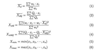
In these equations, (1) will be referred to as the 'regular' mean, (2) not computed in the multiday, (3) as the regular standard deviation, (4) not computed in the multiday, (5) as the minimum, and (6) as the maximum.
The simple statistics also include daily log regular mean, log standard deviation, log QA mean, and log QA standard deviation. These log quantities are calculated as shown in equations (1) and (3), except that x1, x2, ..., xn are replaced by their logarithms.
The histograms and joint histograms report the counts of the pixels falling into predetermined numerical intervals.
The pixel counts are used to represent the number of pixels for the parameters which do not have QA flags, while the confidence-histograms-counts are used to represent the number of counts for each parameter that falls within each QA bin (e.g., questionable, good, very good, and total).