

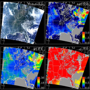
 The MODIS Atmosphere Level 2 Joint Product (ATML2) contains a spectrum of key parameters gleaned from the complete set of standard Level 2 Atmosphere products: Aerosol, Water Vapor, Cloud, Atmospheric Profile, and Cloud Mask. The Joint Atmosphere product was designed to be small enough to minimize data transfer and storage requirements, yet robust enough to be useful to a significant number of MODIS data users. Scientific data sets (SDSs) contained within the Joint Atmosphere product are sampled from the Level 2 Atmosphere products at 5-km and 10-km (at nadir) spatial resolutions (see the Algorithm Overview) for more details regarding the ATML2 spatial resolution and sampling scheme). There are two MODIS L2 Joint Atmosphere data product files: MODATML2, containing data collected from the Terra platform; and MYDATML2, containing data collected from the Aqua platform.
Research and Application
Rather than resorting to the native resolution Atmosphere Level 2 products, MODIS data users wishing to exploit pixel-level retrieval information for spatially and/or temporally large-scale analyses can reduce storage requirements and increase processing efficiency by instead using the ATML2 product. The ATML2 product employs the same 5´5 pixel sampling scheme for the 1km native resolution Level 2 products as is used in the MOD08 Level 3 global aggregated product, an approach that has been shown to retain statistical integrity for multi-day aggregations. This sampling scheme significantly decreases file size while simultaneously preserving pixel-level retrieval information. Moreover, there is pixel-to-pixel correspondence between the ATML2 5km sampled Level 2 data sets (i.e., those at native 1km resolution in the Level 2 products) and the 02SSH 5km sampled Level 1b reflectance/radiance product, providing direct traceability from radiometry to retrieval. In addition, the product enables correlation studies between atmosphere team L2 products without the need to download and store multiple, larger product files.
Data Set Evolution
The ATML2 product was at its inception designed such that a full day of the most widely-used MODIS Level 2 Atmosphere products could fit onto a standard CD-ROM disk. At the time, it was prohibitive for most data users to transfer and store large amounts of the native resolution Level 2 products. As technology has advanced, this need has diminished, and the number of data sets within each ATML2 file, along with the file size itself, has increased. For Collection 6, each ATML2 file now includes sampled data from nearly all Level 2 Cloud Product SDSs and QA information, the final clear/cloudy designation from the Cloud Mask Product, and the primary Level 2 retrievals from the Aerosol (both Dark Target and Deep Blue, including geolocation), Water Vapor, and Atmospheric Profile Products.
Additional Information
Coverage: Global
Spatial Characteristics: 5 and 10-km (parameter dependent)
Temporal Characteristics: Aerosol, cloud phase, and cloud optical parameters are daytime only. Water vapor, cloud top, cloud mask, cloud fraction, cirrus reflectance, and profile parameters are available both day and night.
Key Science Applications: Aerosol climatology, biomass-burning aerosols, cloud radiative properties, hydrological cycle climatology, effect on aerosol and clouds, atmospheric correction, characterization of the atmosphere, cloud parameterization, climate modeling & monitoring, precipitable water, cloud determination and screening.
Key Geophysical Parameters: Atmospheric aerosol optical depth, aerosol size distribution over oceans, cloud particle phase, cloud particle size, cloud optical thickness at 0.66 microns, cirrus reflectance at 0.66 microns, cloud top temperature, cloud top pressure, clear-sky total-column precipitable water derived from both infrared and near-infrared algorithms, and cloud fraction.
Processing Level: 2
Product Type: Post-launch
Maximum File Size: ~8 MB daytime, ~3 MB nighttime
File Frequency: 288/day
Primary Data Format: HDF-EOS